Monday, November 02, 2009

New Zealand

I leave in 19 days. EEK.

Suffice to say, I won't be writing here UNTIL I actually get to New Zealand. Yup, gonna try and update while I'm over there so be sure to check back with this blog AND my other blog.

Speaking of other blog, having a few awesome contests going on right now for a whole bunch of swag and gift cards. Check em out HERE.

Thursday, October 08, 2009

The Otago Penninsula, New Zealand


The gorgeous Otago Penninsula, located along the lengthy, narrow Otago Harbour and near the University city of Dunedin, is one of New Zealand's most underrated jewels.

Volcanic in origin, it forms one wall of the collapsed crater that now forms Otago Harbour. The peninsula lies due east of Otago Harbour and runs parallel to the mainland for 30 km. Its maximum width is 12 km. It is joined to the mainland at the south-west end by a narrow isthmus a little over one kilometre in width.

The suburbs of Dunedin encroach onto the western end of the peninsula, but for the majority of its length it is sparsely populated and occupied by steep open pasture. The peninsula is home to many species of wildlife, notably seabirds, and ecotourism is an increasingly important part of its economy.

When I was touring New Zealand, I made an effort to fit this wonderful place into my plans. I was excited to see sea lions, penguins and the famed albatross on the Elm Lodge Wildlife Tour. This small tour group was the perfect way to experience all the beauty and grandeur that the penninsula had to offer.

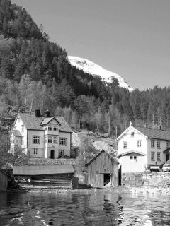
First stop on our journey was just to admire the gorgeousness of the harbour. The first photo I took was the photo that would soon sum up everything about New Zealand. I think it's one of my favourite photos, ever.

(as usual, click on pictures to englarge them)


Next we stopped by a beach where I got to see a penguin...in a box. I don't know where the photo of it went but I assure you it was a penguin in a box. The box was placed there by the Department of Conservation to provide safe nesting places for the blue penguin.

Anyway, our guide lifted up the lid and low and behold, a teeny tiny blue penguin peered up at us.

As if to outdo the penguin, we looked over to the bay where an enthusiastic sea lion provided entertained us with charades.

Here he is being a "torpedo":


Here he is being a "shark":


And here he is doing "yoga":

After the sea lion antics, we visited the Northern Royal Albatross colony, where the mighty albatross come into nest. This is the mainland colony for the albatross in the world.


These mighty birds might look small in these pictures but rest assured these are massive birds that weigh up to 19lbs and have a wingspan of nearly 10 feet! They live to be 40 years old on average and are considered in a "vulnerable" state, though kept off the endangered list thanks to colonies such as this one.


Aside from the albatross - such a stunning sight to see, by the way - the cliffs also housed various other birds, like these gannets:


After we saw the albatross, we drove four-by-four style across some farmers sheep paddock, heading towards a gloriously lit cliff and beach below.


At the beach we came across another sea lion, this one rather close up and "sleeping" - we were safe as long as we didn't get between him and the ocean. Though I think we did!


The main attraction here was the Yellow-eyed penguins that came ashore at dusk every night. Imagine our delight when these mighty birds waddled on shore, like tuxedoed men wearing yellow carnival masks.

And then we saw the sight that could only been seen in New Zealand. An intersection where penguins meet sheep:


If anyone is heading to New Zealand, a tour of the Otago Penninsula is a must-do.

Wednesday, September 23, 2009

Hiking the Franz Josef Glacier, NZ


Another must-do/must-see experience in New Zealand is to go for a hike, or tramp as they call it down under.

New Zealand is world-reknowned for their tramping routes and have a variety of different walks to take, from one day to a week. While I've only done a few short walks (and am gearing up to do the Tongariro Crossing, one of the best walks in the world), one of the most memorable tramps took place on a glacier.

On the Wild West Coast of the South Island, the Franz Josef and Fox Glaciers slowly seep down from their lofty births, down towards the sea and the temperate rainforest of the coast. With 20km seperating the Franz Josef and Fox Glaciers, these are part of only three glaciers*** on earth which come so close to reaching the coastline. Because of this proximity, it makes these glaciers very easy for adventurers to explore.

I signed up with a half-day guided hike which was well worth the money. After strapping on crampons and getting equipped with pick axes and poles, we made our way across scrappy morain and glacial run-off alongside verdant cliffs and flowing waterfalls, to the edge of the mighty icey beast.


Up close, the glacier was massive and awe-inspiring. The terminus loomed up high above us, alternating between dirty crusts and ice-blue crevasses. I was suddenly glad I paid attention in my favourite class in high school - Earth Science - as I still retained a lot of knowledge about glaciers (which I thought would be useless!).

Click to englarge to see funny warning sign


Walking on the glacier was an amazing feeling, having all that *very slowly moving* ice beneath you. Though I was a bit shakey even with my spikey crampons on my feet and a pole to support me, it was thrilling to be able to enter crevasses, climb up ledges of ice and even go through ice holes.


The best part was taking stock of the situation and seeing how far we had really come - the view from the top was amazing, and even though it wasn't sunny like the REAL top of the glacier appeared to be, the contrast between white ice and green rainforest was amazing.


YAY ME!


And now, a little bit of info about the glacier, thanks to Wikipedia: "The glacier is currently 12 km long and terminates 19 km from the Tasman Sea. Fed by a 20 sqm large snowfield at high altitude, it exhibits a cyclic pattern of advance and retreat, driven by differences between the volume of meltwater at the foot of the glacier and volume of snowfall feeding the névé. Due to strong snowfall it is one of the few glaciers in New Zealand which is still growing as of 2007, while others, mostly on the eastern side of the Southern Alps, have been shrinking heavily, a process attributed to global warming.

Having retreated several kilometres between the 1940s and 1980s, the glacier entered an advancing phase in 1984 and at times has advanced at the phenomenal (by glacial standards) rate of 70 cm a day. The flow rate is about 10 times that of typical glaciers. Over the longer term, the glacier has retreated since the last ice age, and it is believed that it extended into the sea some 10,000 to 15,000 years ago.

This cyclic behaviour is well illustrated by a postage stamp issued in 1946, depicting the view from St James Anglican Church. The church was built in 1931, with a panoramic altar window to take advantage of its location. By 1954, the glacier had disappeared from view from the church, but it reappeared in 1997. This is due to the highly variable conditions on the snowfield, which take around 5-6 years before they result in changes in the terminus location."

*** I believe I have actually been to the "other" glacier out of the three on Earth that come so close to the sea, the Jostedal Glacier in Norway. I didn't climb that one though. Been there, done that! :P


Tuesday, September 15, 2009

Exploring the coast of Abel Tasman National Park


My kayak glided across the warm, clear waters which throbbed beneath the potent sun in aquamarine waves. To my left, a tiny blue penguin popped up and swam beside me for a few moments before turning translucent as it slipped under the water and piloted towards rocky islets; on my right were grey granite cliffs topped with rambuncious emerald vegetation and flanked by shimmering yellow beaches of the purest sand.


Tropical waters? Bleached beaches? Penguins?

Where the hell was I?

Abel Tasman National Park is one of the most visited parks in New Zealand, and with good reason. Located in the aptly-named Golden Bay, north of the wonderful hamlet/city of Nelson (which I have been honoured to have visited FOUR times this decade), Abel Tasman National Park encompasses only 225.3 square kilometres, which makes it one of the country's smallest national parks, but - man - have they packed so much beauty into one tight little package. Though most people come to this most gorgeous gem to tramp its famous track, which traverses podocarp forests, clean streams and sandy beaches, others choose to explore the park from the water, via kayaking.


My kayaking experience was with Kiwi Kayaks, one of the many quality companies operating out of Motueka and Maharua, the two towns closest to the park. As of this moment, almost all kayaking operators are conglomerating under one roof to be known as Abel Tasman Kayaking.

Like many good companies offer, I was picked up by bus in Nelson on a sleepy November morning (6:30AM to be exact). With the sun already strong in the wee hours, I knew it was going to be an epic day for exploring the park.

After we stopped in Motueka to pick up more people, we made our way to the coast, to Marahua where we watched the kayaks being hauled off a trailer and on to the golden beach. Because the kayaks had to be tandem and I was alone, I was paired with a fellow backpacker who thankfully had stronger arms than me.


Not that I needed them - kayaking was a breeze. We paddled lazily up the coast, stopping in at sandbars and small islands before beaching ourselves and having a healthy lunch on the silky sands. This was paradise.


Most kayaking tours offer full, half and overnight options and though I cheaped out and went for the most inexpensive version (half day at around $110) I felt I got my money's worth. The gorgeously warm weather helped, as did our affable hosts Steve and Lori (Lori who lived in Vancouver in a previous life) and the stupendous scenery and wildlife that surrounded us with every paddle.


We saw dolphins leaping (my camera wasn't fast enough to capture anything but a splash) off our bows, penguins scooting beside us (wish I could find THAT picture), giant sea birds soaring past, seals playing nearby, and even a wedding held out among a far reaching sand bar.


I firmly believe this park is a must-see for anyone visiting New Zealand - indeed for Kiwis themselves. Whether you kayak or walk, it will truly be a day (or two) that is forever seared in your mind. I remember smiling a LOT that day, and that's something everyone needs to do more often.

Sunday, September 13, 2009

Fraser Island - PART II

Why MORE Fraser Island? Well, because as I just found a lot more photographs that might do more justice to the place than the ones in the previous post ;) Anyway, if you haven't read the post before this, I suggest you do so now, just so you get a sense of things :) - CLICK ON PICS TO ENLARGE


A better look at the beach, which is surrounded by....


Red cliffs...


and shipwrecks....


Time for sand-boarding!!


...afterwards, rinse off the sand in tide pools of water - called champagne pools - which are a warm alternative to swimming in the open ocean - not only would the rough rip tides get you, but there is a very large quantity of Tiger Sharks patrolling the area...we could even see them from the beach!


Of course, you can always combine sandboarding WITH swimming at Lake Wabby


Then explore nearby creeks, such as Eli Creek where you can walk to one point and then float all the way down


Or just go to a normal lake - preferably when it's sunny out


There's always the pool at the Kingfisher Resort, don't forget...


Afterwards, you hope back on that 4X4 bus -


- to see tall trees


- and Kookaburas (who WILL steal your sanwhich out of your hand, btw)


-as well as more Goana lizards


Then it's time for nightlife at the hotel


Before you leave by ferry the next day...

Thursday, September 10, 2009

Fraser Island, Australia

Click on pics to view better


OKaaaay. Bit of a deviation from New Zealand as you and I both know that Australia and New Zealand could not be more different. However, I can't access my NZ pics today (will do so on the weekend) so I thought that at least the two countries are more or less near each other and won't really take away from "New Zealand Month." Even if it does...tough titties.

Pardon the scanned photographs but these were taken before I possesed a digital camera (or really knew anyone that HAD one), back in the day that I was 18/19 years old. It's from my photo album...glad I included captions. These aren't even half of the gorgeous, cool pics I took that day but to be honest I have so many photos all over the place, this will have to do!

Fraser Island is one of the places you MUST go when you visit Australia and judging by the popularity, it seems everyone heeds that call. In fact, I don't know many backpackers who don't go to Fraser Island. Right of passage, you see. Plus it's a designated World Heritage Site for its awesomeness.

Fraser Island is a large sand dune of an island, accessible by passenger ferry outside the nondescript town of Hervey Bay. The whole island is, yes, sand and while there are no roads, those who rent 4x4 vehicles can have a hell of a fun time navigating and camping throughout the island.

I, however, was traveling alone (as I usually do) and couldn't muster up enough strangers to do it independently so I went with a backpacker's tour group...and was glad I did.

Kingfisher Tours does a wonderful job, hosting backpackers in its cramped but clean dorms and treating them to wonderful dinners and lunches each day in its resort (oh and booze and partying). During the day, expeditions are lead out on a huge 4x4 bus.

What can you expect on Fraser Island?

*Sand

*Lakes

*More Lakes (including Lake MacKenzie, so clear and freshwater that you can stare straight down to the bottom...amazing)

*Goanna lizards

*Dingoes (for realz)

*Sand dunes (where you go sandboarding INTO Lake Wabby)

*Booze

*Kookaburas (evil things)

*wild horses (didn't see any)

*Champagne pools

*Tiger sharks

*Shipwrecks

*Rain - just kidding, of course it DID rain almost the entire time we were there. Ah, me and my luck!


Dingoes do eat babies

Goanna Lizards are mighty cool, and nosy!

Most awesome lake ever

Sand boarding, in the rain, down into this lake

Lost in the dunes

Back at the bar

Many storms on Fraser Islands many beaches

More dingoes

Heaven....which is why I look so cracked out

Friday, September 04, 2009

The Banks Penninsula, New Zealand

Have you ever driven past a place, or stood on a country road in some remote part of the country (any country) and thought: "I could hide out here...I could live here for the rest of my life and no one would ever find me?"

click on pics to enlarge


These thoughts often come to me when I feel the globe of the Earth beneath my feet, in my mind's eye can see exactly where I am on a map and realize I am just tucked away in this tiny place on this awesomely huge planet. The next thought that follows is usually: "If I'm ever on the run from the law, this is where I will come."

New Zealand is full of these places and sadly if I ever do rob a bank (to pay off my fashion debt, no doubt), I guess I won't be hard to find since I am posting this.

Anyway, I digress. The Banks Penninsula on New Zealand's South Island is one of those places.


The facts:

The Banks Penninsula sticks out like a spiral from the nearby city of Christchurch, formed eons ago by two volcanic outbursts. It is a gorgeous, stunning and hilly place, accesible by winding roads amidst farms, forests and flowing fields of velvet tussock grass. Punctuating these undulating mounds are many vibrantly blue bays, creating the perfect marriage of land and sea.

The town:

The main town in the area is Akaroa, which is a little bit of France squeezed into the volcanic bay. The French had their eye on New Zealand and hope to colonize it like they did to many South Pacific islands but the British beat them to it first. For this I am grateful... part of New Zealand's charm is it's affable British culture and linguistic ease. However, the French still managed to walk away - sorta - with Akaroa. The town was settled by the French and to this day still bears street names in the language, such as Rue Brittan and Rue Jolie. The town is speckled with wonderful historic buildings and many cafes dot the blindingly azure waters of Akaroa Harbour.


The harbour


French paintings


Street Spirit


Where to stay:

I stayed at the glorious Le Bons Bay Backpackers. This splendid jewel is perched on the spine of a volcanic finger and overlooks the remote and scenic Le Bons Bay.

Le Bons Bay Backpackers


Views of the valley aside, this place is well worth the effort to get to (they will pick you up when you arrange ahead of time but the local taxi is also a lot of fun). You can choose to stay in the gorgeous farmhouse or you can have your own quaint cabin to yourself.


My cabin at Le Bons Bay Backpackers


Every night for a minimal fee, you can take part in the home-cooked meal that the hostel provides - this is wholly recommended as it is fresh, organic and so damn tasty. You all sit around the table too, like a family and it's the perfect way to get to know your fellow travellers. Make sure to bring wine too, though generosity also flows at this place.

Because you are in a very remote area with no access to town, you are (wonderfully) limited with activities. Take advantage of this and read all the books in the library or hang out among the wild grounds.

Reading in one of their many special places


Or go for a walk up nearby roads and soak up the pastoral goodness around you.


Farmland

Fields of Gold

Tussock


One of the best things to do, however, is to sign up for their daily wildlife tour. It costs a mere $35 and the owner takes a handful of people down to Le Bons Bay for a boat tour - putting the boat in the water by tractor, the true Kiwi way.

The trip is amazing...you glide past high craggy cliffs filled with nesting/resting birds and sea lions and then go out to the mouth of the harbour where the wild waves from the South Pacific rush up against the boat. Admist all this turmoil, more times than not, you will see pods of hectors dolphins playing amongst you. Hector's dolphins are endemic to the coastal regions of New Zealand and among the world's smallest. Too cute! Some places in Akaroa actually take you out to swim with these playful pals.

Tractor + Boat

Gannets

Sea lion resting

Tiny fins

Can you see it?

Hector's Dolphin


I have found memories of being out in the boat and feeling the power of the swells coming in, thinking: "There is nothing but ocean between here and Chile" - it was a very profound feeling, punctuated later that night when I saw the lights from a deep-sea shrimp boat bobbing out at sea, a muted shine in the inky blackness of the night sea and sky. I've never felt so remote, like I was literally *this* close to falling off the face of the planet.

How to get there:

Whether you take a car or a bus from Christchurch (www.akaroashuttle.co.nz), the drive along Summit Rd, the lip of the orginal volanic crater, will be one of the highlights of your trip!